
Glacial lake outburst floods (GLOFs): causes and monitoring
How glacial lakes form and fail, how an outburst flood travels down a Himalayan valley, what the October 2023 South Lhonak flood showed, and how lakes are monitored.

High in the Himalaya, thousands of lakes sit behind dams that nobody built, made of loose glacial debris or ice. If one gives way, the lake can drain in minutes and send a flood down valleys full of villages, roads and hydropower plants. For district officials, engineers and students the questions are practical. Which lakes are dangerous? What makes them fail? How fast does the flood travel? And what can be watched, and by whom?
What a glacial lake outburst flood is
A glacial lake outburst flood (GLOF) is the sudden release of water held back by a glacier or a moraine, a ridge of rock, gravel and silt left by a glacier at its edges. The NDMA guidelines note that a moraine dam is far weaker than an engineered earthen dam. It can fail and release a lake over minutes to days, and peak flows of up to 15,000 m³/s have been recorded [1]. Much of the damage comes from the debris the water carries, sometimes far from the lake [1]. A related hazard is the landslide lake outburst flood (LLOF), from a lake behind a landslide that has blocked a river. The difference matters for planning. Glacial lakes stay in fixed places and can be assessed in advance, while landslide dams form without warning [1].
How glacial lakes form
When a glacier thins and retreats, water collects in the hollows it leaves. Inventories group the lakes by what holds them back [1][5]:
- Moraine-dammed lakes sit behind the end (terminal) or side (lateral) moraines. The dams are loose and steep and often contain buried glacier ice. The guidelines rate moraine-dammed lakes at a glacier's snout as having a high probability of outburst [1].
- Ice-dammed lakes are held back by the glacier itself.
- Bedrock-dammed lakes fill rock basins, such as old glacial cirques. Here, the only likely outburst mechanism is a wave pushed out by ice or rock falling into the lake [1].
- Supraglacial lakes form on the glacier surface. They may persist, drain away or recur, and in Sikkim new ones appeared in every year mapped from 2014 to 2017 [5].
Why they are growing
From 1990 to 2018, the number of glacial lakes worldwide grew by 53 %, their area by 51 % and their volume by about 48 % [3]. ISRO counted 2,431 lakes larger than 10 ha in the Indian Himalayan river basins in 2016–17. Of these, 676 had grown notably since 1984, and 130 of those are in India [4]. Research cited by NASA records 85 new glacial lakes in Sikkim between 2003 and 2010 [11].
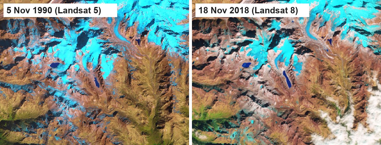
Exposure has grown too. A global study estimates that 15 million people are exposed to potential GLOFs, more than half of them in India, Pakistan, Peru and China. In High Mountain Asia, about 1 million people live within 10 km of a glacial lake [7].
What sets an outburst off
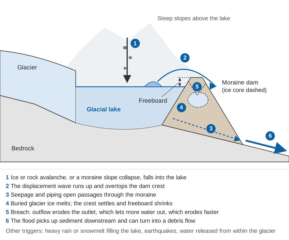
The NDMA guidelines list four conditions that make a moraine-dammed lake hazardous [1]:
- a large lake volume;
- a narrow, high moraine dam;
- stagnant glacier ice buried in the dam;
- limited freeboard, the height between the lake surface and the lowest point of the crest.
Triggers include several processes [1]:
- waves from calving or hanging glaciers and rockfalls;
- settlement of the dam;
- piping, where seepage carries material out of the dam and opens a passage;
- melting of an ice core;
- sudden drainage into the lake from within the glacier;
- earthquakes.
Ice dams fail differently. The guidelines list the ways they open [1]:
- flotation, when the lake gets deep enough to lift the ice and drain beneath it;
- deformation of the ice under water pressure;
- a tunnel melting through or under the ice;
- cracks spreading through the ice;
- tectonic activity;
- water overflowing the ice.
Heavy rain can do it too. The 2013 Kedarnath disaster started at a small seasonal lake above the town, fed only by snowmelt and rain. About 390 mm of rain fell between 10 and 17 June, after four weeks of unusually fast snowmelt, and the lake burst into a debris flow on 16–17 June [8]. A lake does not need a large glacier above it to be dangerous.
Once water starts cutting through a moraine, the failure feeds on itself: a deeper outlet passes more water, which erodes faster. For steep, narrow dams the guidelines consider a large outburst as probable as a small one [1].
How an outburst flood behaves downstream
A GLOF is not just a big river flood:
- The peak is extreme near the lake. At South Lhonak in 2023, the modelled peak at the outlet far exceeded any rain-fed flood estimate for the valley [2].
- It carries sediment and can become a debris flow, a dense slurry of mud, boulders and wood. Large boulders hit bridge piers and dams with great force [2].
- The peak usually shrinks downstream, at a rate set mainly by valley gradient and outflow volume. Rain-fed floods do the opposite and usually grow downstream. In steep reaches, though, the peak can stay high [2].
- Narrow valleys concentrate the energy. The flood cuts into its bed and banks and undercuts slopes, which then slide and add more sediment [2].
For a comparison with other floods, see flash floods vs river floods: how much warning time you get.
South Lhonak and the Teesta, 3–4 October 2023
South Lhonak Lake lies at about 5,200 m in the upper Teesta basin of North Sikkim. It was first noted as a small supraglacial lake in the 1960s and had long been flagged as one of Sikkim's largest, fastest-growing and most hazardous lakes [2][9].
The lake's growth rate doubled, from 0.023 km² per year over 1975–2004 to 0.046 km² per year after 2004 [2]. A 2021 modelling study found that avalanche waves could overtop the frontal moraine. In its large scenario, flow depth at Chungthang, by the Teesta III hydropower station, could reach 25–30 m [9]. Work at the lake included a bathymetric survey in 2014, siphons to lower the level from 2016, and a September 2023 expedition that repeated the bathymetry and installed a weather station and cameras [2].
The sequence below is from the reconstruction by Sattar et al. in Science (January 2025). It is based on satellite elevation models, seismic records, field evidence and modelling [2]:
| Time (IST) | Place | What happened |
|---|---|---|
| 22:12:20, 3 Oct | Lake | About 14.7 million m³ of frozen lateral moraine collapses into the lake |
| Next minutes | Lake | A wave about 20 m high overtops and erodes the frontal moraine, cutting a breach 165 m wide and 55 m deep |
| Next minutes | Outlet | About 50 million m³ drains, roughly half the lake; modelled outflow peaks near 48,500 m³/s |
| ~22:30 | Camp 7.1 km downstream | Flood arrives, matching the time reported there |
| ~00:30, 4 Oct | Chungthang, 67.5 km | Modelled arrival (reported ~00:35); peak about 5,340 m³/s, flow up to 9 m deep and 9 m/s |
| ~noon, 4 Oct | Teesta in Bangladesh | Water levels rise, about 16 hours after the outburst began |
The National Remote Sensing Centre compared radar images from 28 September and 4 October and reported that about 105 ha of the lake had drained [10]. The flood and the landslides it triggered eroded about 270 million m³ of sediment. As a result, the flow volume grew about fivefold [2]. The 1,200 MW Teesta III dam at Chungthang was destroyed and four dams further down were affected. The authors estimate that the Teesta III reservoir added about 5 million m³ of water, roughly 10 % of the outburst volume. They conclude that the outburst water, and above all the eroded sediment, drove the downstream impacts [2]. Post-disaster surveys cited in the study record 55 deaths, 74 people missing, more than 7,025 displaced and 31 major bridges damaged [2]. Rain in the preceding days had saturated the valley slopes [2].
The authors draw two wider lessons. First, the hazard outlives the flood: landslide scars, a raised riverbed and loose deposits leave the valley more exposed. Second, they call for basin-scale early warning, better risk assessment for mountain infrastructure and cross-border cooperation [2].
Worked example. From the collapse at 22:12:20 to arrival at Chungthang at about 00:30 is 2 h 18 min, or 8,280 s. The average speed is 67,500 m ÷ 8,280 s ≈ 8.2 m/s, about 29 km/h. The breach took minutes to form, so the front itself moved somewhat faster.
India's framework: the NDMA guidelines (2020)
NDMA issued its GLOF guidelines in October 2020 [1]. Their main elements are:
- Inventories. Map every glacial lake of 1 ha or more, including catchments beyond administrative borders, in the post-monsoon window when lakes are largest. Keep a catalogue of past outbursts with their triggers and mechanisms. NRSC mapped 2,028 lakes and water bodies over 10 ha (503 of them glacial lakes) across the Indus, Ganga and Brahmaputra basins. The Central Water Commission has monitored 477 lakes over 50 ha monthly from June to October since 2016 [1].
- Risk classification. A first-order assessment over a large area combines lake hazard, exposure and social vulnerability. Hazard covers avalanche potential, lake area as a proxy for volume, dam type and dam steepness. Exposure covers people, roads, farmland and hydropower. On this basis, risk to people is highest in Sikkim and Jammu and Kashmir, and the threat to hydropower is highest in Sikkim. Such lists are snapshots and need regular updating. Critical lakes then get detailed, scenario-based hazard mapping, and the operating procedure classes lakes as highly, moderately or low susceptible [1]. An earlier inventory by Worni et al. covered 251 lakes across the five Indian Himalayan states [6].
- Early warning. An EWS has four elements: risk knowledge, monitoring and warning, dissemination, and response capability. Sensors can be placed at the lake, at the dam or outlet and along the stream. Water-level sensors just below the outlet can detect the start of a breach. Sirens can be complemented by mobile phones. Calibration, drills, maintenance budgets and local ownership are essential. Three sensor-based GLOF warning systems were built in the Himalaya, and none was still operating when the guidelines were written, mainly for lack of local ownership [1].
- Mitigation. Lake levels can be lowered by siphoning, pumping or outlet channels, but cutting a moraine outlet can start the breach it is meant to prevent. Restricting construction in hazard zones is described as a very efficient way to reduce risk at no cost [1].
How lakes are watched in practice
Monitoring works in layers, each on its own timescale:
| Layer | What it shows | Timescale | Main limit |
|---|---|---|---|
| Satellite inventory and change detection | New lakes, growth, drainage, slope movement | Months to years; days for change mapping | Monsoon cloud for optical images; radar sees through it [1] |
| Field surveys and bathymetry | Lake volume, dam structure, outlet condition | Every few years per lake | Access, altitude, season |
| Sensors at the lake | Lake level, weather, camera view of dam and slopes | Minutes | Power, communications, snow, maintenance |
| Level gauges downstream | Arrival and size of a flood wave | Seconds to minutes | Sees the flood only once it has started |
| Trained local observers | Cracks, seepage, new ponds, unusual flow | Continuous | Training and a clear reporting channel |
Satellites built the inventories above. They also showed that the moraine that failed at South Lhonak had been moving at more than 15 m per year since 2016 [2], and they confirmed the drainage from a radar image taken about eight hours after the outburst [10]. Bathymetry gives the lake volume that every flood scenario starts from. The guidelines also suggest registering trekking guides, porters and shepherds as observers, since they visit the lakes far more often than survey teams do [1].
A measurement saves lives only if it reaches people in time. Detection must lead to a decision, and the decision must reach people through sirens, SMS and other channels. People must also know where to go. Every step takes minutes out of the flood's travel time. See how a flood early warning system works and early warning dissemination: sirens, SMS and CAP. The calculator below shows the arithmetic.
With the defaults, the front takes about 2 h 21 min to cover 67.5 km, which leaves about 2 hours after a 15-minute warning chain. At 7 km, the same speed gives under 15 minutes, which the chain alone uses up. Close to a lake, only automatic warnings from sensors at or just below the outlet can help, together with communities who already know their escape routes. GLOF hazard also follows the melt season; see snow and glacier melt: how winter shapes Himalayan river flow.
Key points
- A GLOF is the sudden release of a lake held by a moraine or ice. Peaks of up to 15,000 m³/s have been recorded [1].
- Large volume, a narrow dam, buried ice and low freeboard make a moraine-dammed lake hazardous. Avalanches, piping, ice melt, heavy rain and earthquakes can trigger failure [1][8].
- Glacial lakes are growing in number, area and volume, worldwide and in the Indian Himalaya [3][4].
- Outburst floods pick up sediment, can become debris flows, and leave valleys more hazardous afterwards [2].
- At South Lhonak in 2023, about 50 million m³ was released, and the flood reached Chungthang, 67.5 km away, in about two hours [2].
- NDMA's guidelines call for inventories, regular risk classification and maintained early warning systems with community ownership [1].
ClimMaTech works on flood early warning and river monitoring in Himalayan catchments, where GLOF-prone valleys are part of the landscape. Read more about our flood warning and river monitoring work.
References
- National Disaster Management Authority, National Disaster Management Authority Guidelines: Management of Glacial Lake Outburst Floods (GLOFs), NDMA, Ministry of Home Affairs, Government of India, October 2020. ndma.gov.in
- A. Sattar, K. L. Cook, S. K. Rai et al., The Sikkim flood of October 2023: Drivers, causes, and impacts of a multihazard cascade, Science 387 (6740), eads2659, 2025 (online 30 January 2025). doi.org/10.1126/science.ads2659; accepted manuscript and supplement: eprints.whiterose.ac.uk/224098
- D. H. Shugar, A. Burr, U. K. Haritashya et al., Rapid worldwide growth of glacial lakes since 1990, Nature Climate Change 10, 939–945, 2020. doi.org/10.1038/s41558-020-0855-4
- Indian Space Research Organisation, Satellite Insights: Expanding Glacial Lakes in the Indian Himalayas, ISRO, 22 April 2024. isro.gov.in
- A. Shukla, P. K. Garg, S. Srivastava, Evolution of glacial and high-altitude lakes in the Sikkim, Eastern Himalaya over the past four decades (1975–2017), Frontiers in Environmental Science 6, 81, 2018. doi.org/10.3389/fenvs.2018.00081
- R. Worni, C. Huggel, M. Stoffel, Glacial lakes in the Indian Himalayas: from an area-wide glacial lake inventory to on-site and modeling based risk assessment of critical glacial lakes, Science of the Total Environment 468–469, S71–S84, 2013. doi.org/10.1016/j.scitotenv.2012.11.043
- C. Taylor, T. R. Robinson, S. Dunning, J. R. Carr, M. Westoby, Glacial lake outburst floods threaten millions globally, Nature Communications 14, 487, 2023. doi.org/10.1038/s41467-023-36033-x
- S. K. Allen, P. Rastner, M. Arora, C. Huggel, M. Stoffel, Lake outburst and debris flow disaster at Kedarnath, June 2013: hydrometeorological triggering and topographic predisposition, Landslides 13, 1479–1491, 2016. doi.org/10.1007/s10346-015-0584-3
- A. Sattar, A. Goswami, A. V. Kulkarni et al., Future Glacial Lake Outburst Flood (GLOF) hazard of the South Lhonak Lake, Sikkim Himalaya, Geomorphology 388, 107783, 2021. doi.org/10.1016/j.geomorph.2021.107783
- Indian Space Research Organisation / National Remote Sensing Centre, Satellite image-based studies of South Lhonak Lake, ISRO, 4 October 2023. isro.gov.in
- NASA Earth Observatory, As a Himalayan Glacier Melts, a Lake Grows, Image of the Day, 26 April 2019. science.nasa.gov