
Types of rain gauges used in India and how they work
The manual gauge read every morning, the siphon chart recorder, the tipping bucket behind automatic stations, weighing gauges and the newer optical and acoustic sensors: what each one measures and where it fits.

A block office needs rainfall totals to settle a crop-loss claim. A district disaster cell wants rain-intensity alerts for a landslide-prone road. A student wants to know why the hydrology textbook lists so many kinds of gauge. All three start with the same question: which rain gauge is used in India, and does it give the number they need?
India uses several types side by side. The backbone is a simple manual gauge read once a day at 08:30 IST. Recording gauges, which also capture when the rain fell, range from clockwork siphon recorders to the tipping-bucket gauges of IMD's automatic network. Weighing, optical and acoustic gauges complete the picture. This article explains how each works, what it records, its strengths and limits, and how a gauge should be installed under the Indian code.
Which rain gauge is used in India?
The standard rain gauge in India is the non-recording gauge made to the Bureau of Indian Standards (BIS) specification IS 5225. A non-recording gauge collects and stores the rain, and an observer measures it by hand. A recording gauge also records when the rain fell, so that intensity can be worked out.
Three BIS product standards cover rain gauges, all from the meteorological instruments committee [3]:
| Standard | Covers | Current edition |
|---|---|---|
| IS 5225 | Rain gauge, non-recording | 2024 (second revision) |
| IS 5235 | Rain gauges, recording (natural-siphon type) | 2025 (second revision) |
| IS 18627 | Tipping bucket rain gauges | 2024 |
A fourth, IS 4986:2002, is the code of practice for installing a non-recording gauge and measuring the rain [4]. The design details below come from the 1992 editions of IS 5225 and IS 5235, which are freely available [1][2].
Indian gauges are uniform for a reason. The foreword of IS 5225:1992 records that the Director General of Meteorology had been designated the sole authority for correct rainfall registration in India, that the India Meteorological Department (IMD) tested and certified rain gauges made in the country, and that registration authorities had been told to use only IMD-certified gauges [1]. IMD still guides states and central agencies on procuring and installing standard equipment, and inspects rain gauge stations [9].
The standard manual gauge (IS 5225)
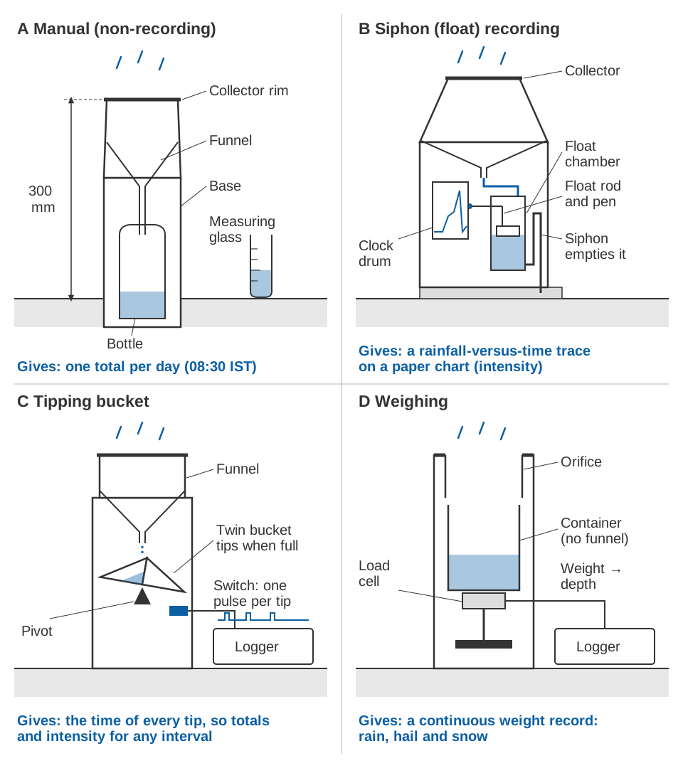
How it works. The gauge has a collector, a funnel whose machined rim defines the catching area, and a receiver, a base fixed partly below ground that holds a polythene bottle [1]. Rain inside the rim runs into the bottle. Each morning the observer pours it into a rain measure, a measuring glass graduated in millimetres of rain for that collector size [1][5].
IS 5225:1992 specifies two collectors, of 200 cm² and 100 cm² [1]. From the standard's drawings, the rim's inside diameter is 159.6 mm for the larger and 112.9 mm for the smaller, and it must be correct within ±0.5 mm in any direction, with the mean of four measurements within ±0.2 mm [1]. The tolerance matters because rainfall is volume divided by rim area: a rim 1 % too large in area reads 1 % high every day.
What it records. One number: the rain since the last reading. Under IS 4986 the gauge is read at 08:30 IST every day, even when the observer thinks no rain fell, to the nearest 0.1 mm, and the amount is entered against the date of measurement [4]. The WMO Guide to Instruments and Methods of Observation (WMO-No. 8) likewise asks for daily amounts to 0.2 mm, and to 0.1 mm where feasible [5].
Worked example: collector area and capacity. With 1 cm³ = 1 mL:
depth (mm) = 10 × volume (mL) / area (cm²)

200 cm² collector:  1 mm of rain = 20 mL
100 cm² collector:  1 mm of rain = 10 mL

4-litre bottle, 200 cm² collector:   10 × 4 000 / 200  =   200 mm
4-litre bottle, 100 cm² collector:   10 × 4 000 / 100  =   400 mm
10-litre bottle, 100 cm² collector:  10 × 10 000 / 100 = 1 000 mm
These are the nominal capacities in IS 5225 (100, 200, 400 and 1 000 mm), built from two collectors, two bases and bottles of 2, 4 and 10 litres [1]. The standard says the 200 mm gauge suits most stations and recommends the 400 mm and 1 000 mm versions, with the smaller collector, for heavy and very heavy rainfall areas [1]. A bottle that overflows on a 300 mm day loses the most important record of the year.
Strengths and limits. No power, no electronics, nothing to drift except the rim and the glass. It is cheap, gives long consistent records, and is the gauge automatic gauges in India are checked against [7]. But it says nothing about intensity or timing, needs an observer every day, and its data arrive only when someone reports them.
What is a recording rain gauge?
A recording rain gauge keeps a continuous record of accumulated rainfall against time, from which intensity, the rate of rainfall in mm/h, is calculated. WMO-No. 8 lists three automatic types in general use: weighing, tipping bucket and float [5]. The Indian standard for recording gauges, IS 5235, covers the float type with a natural siphon [2].
The siphon (float) gauge, IS 5235
How it works. Rain runs into a float chamber holding a light metal float. As the water rises, a pen on the float rod draws a line on a chart wound round a clockwork-driven drum. When the chamber is full, a siphon empties it at once, the pen drops to zero and recording resumes [2]. WMO-No. 8 says siphoning should start precisely at the set level and take no more than 15 s, and that such gauges normally record over 24 hours [5].
| IS 5235:1992 version | Collector area | Rim diameter | Rain per siphoning |
|---|---|---|---|
| 10 mm gauge, light or medium rainfall | 325 cm² | 203 to 203.4 mm | 10 mm |
| 25 mm gauge, heavy rainfall | 130 cm² | 128.5 to 128.6 mm | 25 mm |
Both siphon at the same volume (325 cm² × 1.0 cm = 130 cm² × 2.5 cm = 325 mL; the standard gives 324.9 ± 3.2 cm³), and in both the float rises 60 mm from zero to discharge [2]. The 10 mm gauge therefore draws a finer trace.
What it records. A mass curve: accumulated rainfall against time, whose slope is the intensity. The 1992 foreword describes it as the recording gauge most commonly in use in the country [2].
Strengths and limits. It gives intensity without electricity, on a chart anyone can inspect. But charts must be changed by hand and digitised before analysis, the clock must keep time, and the siphon must start and stop cleanly [2][5]. The record exists only on paper at the site, so it cannot feed a warning.
How does a tipping-bucket rain gauge work?
A tipping-bucket gauge funnels rain into a small two-compartment bucket on a pivot. When one compartment holds a set amount, the bucket tips, empties and brings the other compartment under the funnel. Each tip closes a switch and sends one pulse to a data logger [5]. The amount per tip is the resolution; WMO-No. 8 advises no more than 0.2 mm where detailed records are needed [5].
Where it is used in India. IMD's automatic rain gauge (ARG) network. An IMD paper at a 2010 WMO instruments conference describes the first phase: 1 350 ARG stations installed in 2008–10, each with a stainless-steel tipping bucket with a 20 cm collector and 0.5 mm resolution, sending hourly and daily rainfall by satellite [6]. The daily count resets at 03:00 UTC [6], which is 08:30 IST, so the automatic total matches the manual observing day.
Collector area = π × (20 cm / 2)² = 314 cm²
Water per tip  = 314 cm² × 0.05 cm = 15.7 mL   (0.5 mm of rain)
The paper gives the same 15.7 cm³ [6]. Tipping-bucket gauges now have their own Indian standard, IS 18627:2024 [3].
Strengths and limits. Little power, and pulses that are easy to log and transmit, make it the usual choice for automatic stations [5]. Its errors are well known: water lost while tipping in heavy rain, coarse resolution in light rain, and evaporation, wetting and an unlevel gauge biasing the count. Uncorrected gauges under-read intensity in heavy rain and over-read it in light rain, so WMO recommends dynamic calibration with an intensity-dependent correction [5]. These errors, with siting and calibration, are covered in tipping-bucket rain gauges: errors, siting and calibration.
How well do automatic and manual gauges agree in India? At 11 Karnataka stations where both stood together, 24-hour totals differed by a bias within ±5 mm at eight stations and within ±20 mm at three, with no statistically significant difference in the means at 95 % confidence [7].
Weighing gauges
How it works. A container sits on a weighing mechanism (a spring or balance in older designs; an electronic element that deforms only elastically in modern ones), and the weight of everything that falls in is recorded continuously [5]. One gram of water over 10 cm² is 1 mm of rain [5], and intensity comes from the change in weight between readings [5].
What it records. Precipitation of every kind. WMO-No. 8 says it is the only one of the three classic automatic types satisfactory for all forms of precipitation, because snow and hail are weighed as they fall [5]. That makes it the type to consider at high Himalayan sites where winter precipitation falls as snow.
Strengths and limits. No tipping mechanism and little wear, so calibration is seldom needed [5]. But most models do not empty themselves (capacity 250 to 1 500 mm, depending on the model), so they need servicing, oil against evaporation and, in the cold, antifreeze. Wind can make the container oscillate ("wind pumping"), wet snow can stick to the rim, and the output's response time, from about six seconds to a few minutes, delays intensity readings [5].
Optical, disdrometer and acoustic gauges
A newer group measures precipitation without moving parts, and often without collecting it. WMO-No. 8 lists devices using capacitance sensors, pressure transducers, acoustic and optical sensors, and small radar [5].
- Optical gauges and disdrometers detect falling precipitation optically, for example by optical scattering [5]. A disdrometer characterises the drops themselves, their size distribution [5], and some optical disdrometers can tell liquid from solid precipitation [8].
- Acoustic and impact sensors respond to drops striking a sensing surface instead of collecting the water [5][8].
WMO-No. 8 says these instruments resolve intensity more finely than classic gauges, from 0.01 mm, need less maintenance, and perform about as well as a conventional tipping bucket [5]. A WMO field intercomparison at Vigna di Valle, Italy, from October 2007 to April 2009, adds a caution. Against a reference built from four pit gauges, processed tipping-bucket and weighing gauges performed acceptably, but none of the non-catching gauges agreed well. The disdrometers tended to overestimate intensity: precise, but less accurate than conventional gauges. They did need little maintenance, which suits unattended stations [8].
Comparison of rain gauge types
| Type | What it records | Strengths | Limits | Where it fits |
|---|---|---|---|---|
| Manual non-recording (IS 5225) | One total per day (08:30 IST) | No power; simple; long consistent records | No intensity or timing; daily observer; delayed reporting | Daily rainfall stations; check gauge beside automatic ones |
| Siphon recording (IS 5235) | Rainfall against time on a paper chart | Intensity without electricity | Charts handled by hand; clock and siphon faults; no real-time data | Intensity records at staffed stations |
| Tipping bucket (IS 18627) | Time of each tip: totals and intensity | Low power; easy to log and transmit | Losses in heavy rain; coarse in light rain; needs calibration and cleaning | Automatic stations, including IMD's ARG network |
| Weighing | Continuous accumulated weight | Rain, hail and snow; few moving parts | Emptying, oil, antifreeze; wind pumping; response delay | Snow or hail; research |
| Optical, disdrometer, acoustic | Rain rate; often drop sizes | Fine resolution; low maintenance | Weaker agreement with reference gauges in trials | Research; unattended sites beside a catching gauge |
How many gauges an area needs, and what share of them should be recording gauges, is covered in how many rain gauges does a district need.
Same rain, two records
The difference between a daily total and an intensity record is clearest over one day. The chart is illustrative, not a real station.
For a monthly water balance, 62 mm is enough. For urban drainage or a flash-flood catchment, the 41 mm in three hours is what matters, and WMO-No. 8 notes that such uses need far finer time resolution, typically 1 minute for intensity [5].
How should a rain gauge be installed?
IS 4986:2002 sets the rules for the manual gauge. A Government of Haryana procedure prepared from it summarises them [4]:
- Rim height. Cement the base into a 600 × 600 × 600 mm masonry or concrete foundation so that the rim is horizontal and exactly 300 mm above ground. Lower, and rain splashes in; higher, and wind eddies reduce the catch.
- Obstacles. Keep the gauge generally four times the height of the nearest object away from it, and never less than twice. WMO-No. 8 gives the same minimum of twice the obstacle height [5].
- Ground. Level ground, not a slope or terrace, and never where the ground falls away steeply on the windward side. On a mountainside, pick a patch whose slope and orientation match the surroundings.
- Floods and animals. In flood-prone areas, keep the gauge 300 mm above the highest flood line. A cattle fence should be no taller than half its distance from the gauge.
- Records. Sketch surrounding objects with their heights and distances, and inspect at least twice a year, once before the monsoon.
The IS 5235 drawing puts the siphon recorder on a 75 mm concrete platform with its rim about 750 mm above ground [2], so manual and recording gauges at one site do not catch at the same height; remember that when they disagree. WMO-No. 8 puts the wind error over the gauge mouth at typically 2 to 10 % for rain, and uses pit gauges, with the rim at ground level, as the reference for rain because they nearly eliminate it [5].
Key points
- India's standard rain gauge is the manual non-recording gauge of IS 5225, with a 200 cm² or 100 cm² collector, read daily at 08:30 IST.
- Recording gauges give intensity. The traditional Indian type is the siphon chart recorder of IS 5235; IMD's automatic rain gauges use tipping buckets.
- Tipping buckets are easy to log and transmit but need calibration at high and low intensities; weighing gauges handle snow and hail but need regular servicing.
- Optical, disdrometer and acoustic sensors offer fine resolution and low maintenance, but agreed less well with reference gauges than corrected catching gauges in WMO trials.
- Installation decides much of the accuracy: level rim 300 mm above ground, obstacles at least twice and preferably four times their height away (IS 4986).
Where ClimMaTech fits
Rainfall is one input to the river monitoring and flood warning work we do with water resources and disaster management departments, and the right gauge depends on the job: a daily total for the record, or intensity in real time for a warning. Our automatic weather station, VARSHAQ, which includes rainfall measurement, is in development.
References
- Bureau of Indian Standards, IS 5225:1992 Meteorology – Raingauge, non-recording – Specification (first revision), BIS, 1992 (reaffirmed 2003; superseded by IS 5225:2024). Clauses 1, 3, 4, 6.1.1 and Figures 1–2; foreword. law.resource.org (archived copy).
- Bureau of Indian Standards, IS 5235:1992 Meteorology – Raingauges, recording – Specification (first revision), BIS, 1992 (superseded by IS 5235:2025). Clauses 3, 4, 8.3.1, Table 1 and Figure 1; foreword. law.resource.org (archived copy).
- Bureau of Indian Standards, Know your standards: IS 5225:2024 Meteorology – Rain gauge, non-recording – Specification (second revision); IS 5235:2025 Meteorology – Raingauges, recording – Specification (second revision); and the Meteorological Instruments Sectional Committee (PGD 21) list of standards, which includes IS 18627:2024 Tipping bucket rain gauges – Specification. BIS.
- Atal Bhujal Yojana Haryana, Irrigation and Water Resources Department, Government of Haryana, Standard Operating Procedure: Rain gauge installation and measurement, prepared from IS 4986:2002 Installation of raingauge (non-recording type) and measurement of rain – Code of practice. hid.gov.in.
- World Meteorological Organization, Guide to Instruments and Methods of Observation, Volume I: Measurement of Meteorological Variables, Chapter 6 "Measurement of precipitation", sections 6.1–6.5, WMO-No. 8, 2024 edition. WMO e-Library.
- A. Anjan, R. Pratap, U. K. Shende and R. D. Vashistha (India Meteorological Department), Comparison of Automatic Raingauge Station with Observatory and its performance in Indian Subcontinent, WMO Technical Conference on Meteorological and Environmental Instruments and Methods of Observation (TECO-2010), Instruments and Observing Methods Report No. 104, WMO, 2010. wmo.int.
- G. Agnihotri and J. Panda, Comparison of rainfall from ordinary and automatic rain gauges in Karnataka, MAUSAM, 65(4), 575–584, 2014. doi:10.54302/mausam.v65i4.1205.
- L. G. Lanza, E. Vuerich and I. Gnecco, Analysis of highly accurate rain intensity measurements from a field test site, Advances in Geosciences, 25, 37–44, 2010. doi:10.5194/adgeo-25-37-2010.
- India Meteorological Department, Hydrometeorological services in IMD, IMD. mausam.imd.gov.in.