
The National Hydrology Project (NHP) explained
What India's World Bank-supported National Hydrology Project is, which ministry runs it, what it paid for and what it left behind.

Anyone who works with river, rainfall or groundwater data in India soon meets the abbreviation NHP. It appears in tender documents, in station names on public dashboards and in the credits of national data portals. The National Hydrology Project (NHP) is a central government scheme, supported by a World Bank loan, that set out to give India more water data, better data and easier access to it. This article explains what it is, who runs it, how the money was arranged and what it delivered, using the project's own documents.
What is the National Hydrology Project (NHP)?
The National Hydrology Project is a nationwide programme to build the data systems that water management depends on: stations that measure water, centres that store and check the readings, and tools that turn them into forecasts and plans. The Union Cabinet approved it on 6 April 2016 as a central sector scheme, one paid for from the central budget, with a total outlay of Rs 3,679.7674 crore. Of this, Rs 3,640 crore was for the project itself and Rs 39.7674 crore for the National Water Informatics Centre (NWIC), the national repository of water data [1].
It followed two earlier World Bank-supported hydrology projects, Hydrology Project I (1995 to 2003) and II (2004 to 2014) [2]. Those covered only 13 states [1]. The Central Water Commission (CWC) lists the gaps the new project was meant to close: large areas not covered by the earlier phases, including the Ganga basin states, the Himalayan region, the North Eastern states and the Indus basin, and a lack of uniform standards between states [2].
The World Bank states the project's development objective as: "Improve the extent, quality and accessibility of water resources information and to strengthen the capacity of targeted water resources management institutions in India" [5][3].
National Hydrology Project: under which ministry?
The National Hydrology Project sits under the Ministry of Jal Shakti, in its Department of Water Resources, River Development and Ganga Rejuvenation [2][5]. When the Cabinet approved it in 2016, the same department belonged to the Ministry of Water Resources, River Development and Ganga Rejuvenation [1]. The Central Water Commission is one of the implementing agencies and acts as the central technical coordinating agency [2].
The project was never run by one body. It had 48 implementing agencies: 12 central agencies (three of them river basin organisations) and 36 state and union territory agencies [3][4]. Each state agency bought and ran its own stations and data centre under a common national framework. That is why the same project shows up in the paperwork of many different state departments.
How does the National Hydrology Project work with the World Bank?
Half of the scheme's outlay was a World Bank loan, repaid by the Central Government. The other half was central budget support. Both portions were passed to states and central organisations as grants [1]. A simple check from the Cabinet figures:
Total outlay        Rs 3,679.7674 crore
World Bank share    50 % = Rs 1,839.8837 crore   (matches the Cabinet release [1])
The World Bank approved the loan (number IBRD-87250) on 15 March 2017. It became effective on 5 May 2017 and closed on its planned date, 31 March 2025 [3][5]. Its history is a good example of how a large loan changes over time:
| Item | US$ million |
|---|---|
| Original loan | 175.00 |
| Cancelled at the first restructuring (2021) | 15.00 |
| Cancelled at the second restructuring (March 2025) | 15.00 |
| Expired undisbursed at closure | 10.74 |
| Disbursed (175.00 − 15.00 − 15.00 − 10.74) | 134.26 |
The cancellations were attributed to savings from exchange-rate movements and procurement efficiencies [3]. The World Bank's independent evaluators describe the money as disbursed at 134.26 million of a total project cost of about 279 million once the borrower's own contribution (US$145 million) is counted [3]. As a share of the original loan, the amount used was 134.26 / 175 = 77 %.
The project was planned for eight years, 2016-17 to 2023-24. The Department of Expenditure later approved an extension of the scheme to September 2025 within the same allocation [4].
What are the four components of NHP?
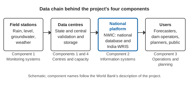
The project had four components. The figures below are US$ million at appraisal and at completion, as reported by the World Bank's independent evaluators [3].
- Water Resources Monitoring Systems. Expanding and modernising networks for rainfall and weather, river flow, groundwater, water quality and storage: moving from manual readings to real-time sensors with satellite or cellular telemetry, plus laboratory equipment, data centres and digitisation of historical records.
- Water Resources Information Systems. Strengthening India-WRIS, the national web platform, and linking state platforms to it, with a protocol that defines which data are open and which are restricted.
- Water Resources Operations and Planning Systems. Models and decision support tools for real-time flood forecasting, reservoir operation, irrigation management, basin water accounting, and groundwater and coastal management.
- Institutional Capacity Enhancement. New centres of excellence (for example flood forecasting at CWC and a groundwater modelling centre at the Central Ground Water Board), training, and project management at national, basin and state level.
The chart shows where the money went. Monitoring systems took by far the largest share and were close to plan, while the modelling and decision-support component spent less than a third of its estimate [3].
What did the National Hydrology Project deliver?
Results depend on who counts and when, so it helps to follow the numbers through time.
- December 2020, mid-term. Contracts had been awarded for 6,500 real-time hydro-meteorological stations (rainfall and weather, and water level and discharge), of which 1,900 were installed. 12,273 surface water stations were mapped in India-WRIS, against 878 in 2016, and 70,525 groundwater stations had started sharing data [6].
- January 2025, weeks before the loan closed. The World Bank's final status report gives results as of 31 January 2025, against the closing targets [5]:
| Indicator | Achieved | Target |
|---|---|---|
| Stations providing validated data online (increase) | 12,540 | 7,630 |
| Groundwater stations (reported separately) | 8,550 | 4,690 |
| Meteorology stations (reported separately) | 2,440 | 1,380 |
| Surface water stations (reported separately) | 1,600 | 1,560 |
| Advanced flood forecasting systems for river basins | 7 | 7 |
| Water data centres functioning satisfactorily | 25 | 20 |
| Professionals trained | 2,340 | 2,000 |
- Final evaluation. The independent review reports that the flood forecasting count reached 10 basins, that 22 State Water Informatics Centres were established, that real-time monitoring covered 600 major and medium reservoirs, and that bathymetric surveys assessed the capacity of about 400 reservoirs, roughly half of India's gross storage [3]. It also reports 53 SCADA systems (supervisory control and data acquisition) commissioned and 15 new water quality laboratories [3].
- December 2025, ministry summary. The ministry reports 23,562 real-time data acquisition system (RTDAS) surface water and groundwater stations installed, 5,667 piezometers constructed, 134 water quality laboratories built or strengthened and 23 State Water Informatics Centres formed [4].
These totals are not the same measure, so they should not be added or compared directly. The World Bank counts the increase in stations giving validated online data (and reports each station type as its own indicator, so the rows above do not add exactly to the total), while the ministry counts stations installed [4][5]. Both agree on the direction: a country that in 2016 mapped 878 surface water stations in its national information system now reports data from thousands.
The Cabinet note also promised outcomes: lead time of flood forecasts extended from one day to at least three days, flood inundation mapping for disaster managers, and seasonal yield forecasts for reservoirs [1]. Those were expectations at approval. Where forecasts improve depends on each basin and each forecasting method, and the completion review reports operational forecasting tools in use rather than a single national lead-time figure [3].
The World Bank's independent evaluators rated the outcome Satisfactory and efficacy High, and estimated an economic internal rate of return of 27.6 % [3].
What is a real-time data acquisition system (RTDAS) in NHP?
An RTDAS is a station with automatic sensors and a communication link (satellite or cellular, as the project describes it) that sends readings to a central receiving system without anyone visiting the site [3][6]. It was the biggest single item in the monitoring component. NHP also paid for the layers above the station: data centres, validation, the national database and India-WRIS. We describe the station-side technology in what is an RTDAS and how states have used it in real-time data acquisition systems in Indian states. For the portals that publish the data, see open water data in India.
What does NHP mean for Himalayan states and hill catchments?
The Himalayan region was named as a gap in the earlier hydrology projects, and the new project was designed to reach it [2]. Two examples from the ministry's own summary show the range of the work. CWC's monitoring of glacial lakes and water bodies grew from 902 to 2,843 in 2025, using the NRSC Glacial Lake Atlas of Indian Himalayan River Basins produced under NHP; the same summary lists 17 of the 681 glacial lakes in India as being in Himachal Pradesh [4]. And the project paid for high-resolution elevation models, a network of continuously operating reference stations and a geoid model, which all feed flood mapping [4]. Hill catchments respond within minutes to hours, so station density and fast telemetry matter more there than in the plains; see river monitoring in hill and Himalayan catchments.
What did the evaluators say could go wrong?
The independent review is candid about the risks that remain [3]:
- Funding of operation and maintenance. Stations and data centres need yearly money for contracts and staff. Existing O&M contracts were expected to cover the next three to five years, and long-term continuity depends on governments putting these costs in their own budgets.
- Interoperability and cybersecurity. Some platforms still struggle to work with each other and with newer tools such as AI forecasting and remote sensing.
- Data fragmentation. Without continued central coordination by NWIC, lapses in data quality may return.
- Capacity. Staffing gaps at state and central level slowed implementation, and trained people must stay in post.
Data quality is a daily concern for any network this size; we cover the common faults in data quality control for hydromet time series.
Key points
- NHP is a central sector scheme of the Ministry of Jal Shakti (Department of Water Resources, River Development and Ganga Rejuvenation), approved by the Cabinet on 6 April 2016 with an outlay of Rs 3,679.7674 crore.
- Half the outlay was a World Bank loan. The loan was US$175 million at approval, US$134.26 million was disbursed, and it closed on 31 March 2025.
- It had four components: monitoring systems, information systems, operations and planning tools, and institutional capacity. Some 48 central and state agencies implemented it.
- Its main legacy is a national data backbone: thousands of automatic stations, state and national data centres and the India-WRIS platform.
- Keeping the network alive depends on maintenance budgets, data standards and trained staff rather than on new hardware alone.
Where ClimMaTech fits
At ClimMaTech we build monitoring and warning systems for rivers and hill catchments, and the stations an NHP-style network depends on are the kind of equipment we work with. Our RTDAS and hydromet telemetry solution describes how real-time stations, data delivery and alerts fit together for departments that run such networks.
References
- Press Information Bureau, Government of India, National Hydrology Project (Cabinet decision), 6 April 2016. pib.gov.in
- Central Water Commission, Ministry of Jal Shakti, National Hydrology Project (NHP). cwc.gov.in
- World Bank Independent Evaluation Group, National Hydrology Project, Implementation Completion Report Review, Report ICRR0024796, 2026. documents1.worldbank.org
- Press Information Bureau, Ministry of Jal Shakti, Achievements of the DoWR, RD & GR for the year 2025 (item 14, National Hydrology Project), 30 December 2025. pib.gov.in
- World Bank, Implementation Status & Results Report, National Hydrology Project (P152698), Sequence 17, archived 28 March 2025 (results as of 31 January 2025). documents1.worldbank.org
- Press Information Bureau, Ministry of Jal Shakti, Union Minister of Jal Shakti reviews progress made under National Hydrology Project in its mid-term, 16 December 2020. pib.gov.in