
RTDAS in Indian states: how real-time data networks work
What a state real-time data acquisition system is made of, how the National Hydrology Project paid for the first wave, and what keeps the networks running afterwards.

If you search for a real time data acquisition system for Rajasthan, or for any other state, you will land on tender notices, Water Resources Department pages and a good deal of acronym soup. What is an RTDAS, who builds one, and what do the official documents actually require? This article answers those questions from the published tender and programme documents of the Central Water Commission (CWC), state water resources departments and the World Bank-assisted National Hydrology Project (NHP).
What is an RTDAS (real time data acquisition system)?
An RTDAS is a network of automatic hydrological and meteorological stations that send their readings to a central receiving station within minutes, instead of waiting for an observer to write them in a register. Maharashtra's Hydrology Project describes it as the process of obtaining hydro-meteorological measurements from remote stations and transmitting them to a central receiving station in real time [3]. In the tender documents we read, the measured quantities are rainfall, river water level (stage), river discharge, reservoir level and outflow, and climate parameters, and the data are relayed over satellite (INSAT) and mobile (GSM/GPRS) links [1][3][4].
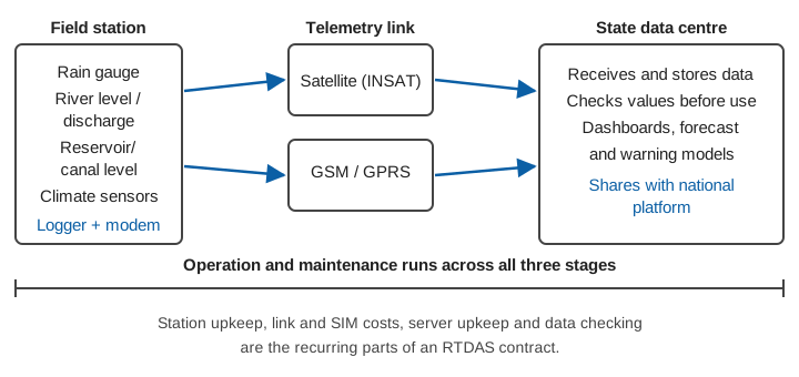
Every RTDAS, whichever state buys it, has the same three stages (Figure 1):
- Field stations with sensors, a data logger and a modem. A single station may carry a rain gauge, a river level sensor or both. The CWC's 2021 tender for eight stations in the Cauvery and southern rivers organisation, for example, asks for data loggers with two analogue input channels and INSAT, GSM and GPRS telemetry [2].
- Telemetry links, normally more than one. The satellite link covers places with no mobile signal; the mobile link is cheaper where there is coverage. How to choose between them is covered in telemetry link design for hydromet stations.
- A data centre that receives, stores and checks the data and passes it to dashboards and models. The same 2021 tender specifies data-centre equipment at the state's modelling centre in Kochi, a display system in the Chief Engineer's office in Coimbatore and a high-speed internet connection with a static IP for five years [2].
For a wider tour of the same idea, see what an RTDAS is and what it does, and from sensor to screen for the data path.
Who pays for state RTDAS networks in India?
Much of the first wave of state networks was paid for under the National Hydrology Project. According to the World Bank's independent review, the project's stated aim was to improve "the extent, quality and accessibility of water resources information" and to strengthen the capacity of targeted water resources institutions. Its monitoring component supported moving data acquisition for rainfall, streamflow, groundwater, water quality and storage from manual to real-time [8]. The project was approved on 15 March 2017 and closed on 31 March 2025 [8].
The Union Ministry of Jal Shakti described the plan at the project's mid-term in December 2020: contracts had been awarded for 6,500 real-time hydro-meteorological stations, of which 1,900 had been installed [5]. By its year-end review for 2024 the Ministry reported that almost 22,960 RTDAS surface-water and groundwater stations had been installed in the country [6]. A World Bank status report of August 2024 gave a slightly different picture, because it counts differently: 23,650 RTDAS procured, of which 16,000 were in operation [7].
| Source and date | What it counted | Figure |
|---|---|---|
| Ministry of Jal Shakti, December 2020 [5] | Stations contracted / installed | 6,500 / 1,900 |
| World Bank status report, August 2024 [7] | RTDAS procured / in operation | 23,650 / 16,000 |
| Ministry of Jal Shakti, year-end review 2024 [6] | Surface-water and groundwater RTDAS installed | almost 22,960 |
| World Bank independent review, 2026 [8] | Stations giving validated real-time data online (target 7,630) | 12,540 |
The figures answer different questions: "contracted", "installed", "in operation" and "validated data online" are not the same thing. The difference between 23,650 procured and 16,000 in operation in the August 2024 report [7] is exactly the gap that the rest of this article is about.
What do state RTDAS tenders ask for?
Public tender documents show the pattern. Three examples, all from official sources:
Central Water Commission, western India (2017). The CWC's Narmada and Tapi Basin Organisation invited bids for real-time data acquisition at 18 water level and meteorological stations and 6 meteorological stations in 12 river basins across Gujarat, Madhya Pradesh, Rajasthan, Maharashtra and Daman and Diu. The work was turnkey: equipment, software and civil works, with satellite and GSM telemetry, a two-year warranty and five years of maintenance afterwards [1]. This is one reason a search for Rajasthan leads to CWC documents as well as to the state's own: the central network and the state networks sit side by side in the same river basins.
Central Water Commission, Cauvery and southern rivers (2021). Eight rain gauge and water level stations, again with INSAT, GSM and GPRS telemetry. The contract was written in the other direction: a five-year comprehensive warranty with two further years of maintenance, a data centre at the modelling centre and a minimum of ten years of service support after commissioning [2].
Maharashtra Water Resources Department. The state's Hydrology Project describes a proposed RTDAS for the Krishna and Bhima sub-basins of 266 stations in total: 113 in the Krishna and 153 in the Bhima. They include automated rainfall stations (67 and 82), river level and discharge stations (13 and 18), reservoir level and outflow stations (19 and 27) and full climate stations (14 and 26). Some are upgrades of existing stations and some are new. The objectives listed include a real-time data centre at Pune, software to evaluate real-time data before it reaches forecasting models, and training of state staff so that they can operate the equipment if the state takes over its upkeep [3].
Goa Water Resources Department. A 2019 tender under the NHP sought an RTDAS for the canal system of the Tillari Irrigation Project [4]. It is a useful reminder that these networks are not only about floods: canal operators use the same architecture to see what reaches the tail end.
Read together, the documents share four features. Telemetry is redundant (satellite plus mobile). Warranty and operation and maintenance are bought together with the equipment. A data centre is part of the package, not an afterthought. And the people who will run it are expected to be trained [1][2][3].
Why do some stations stop reporting?
Buying stations is the easy part. The World Bank's own review is blunt about the next stage: existing operation and maintenance contracts "are expected to cover the next 3-5 years", several states have already committed resources to expand their systems, but "long-term sustainability will depend on governments fully internalizing O&M within their budget cycles" [8]. It also notes reliance on outsourced IT teams and pending approvals in some states as risks, and that the digital infrastructure needs regular upgrades [8].
For an engineer reading a tender, that translates into practical questions:
- Who owns the station after the warranty ends? A budget line for spare sensors, SIM and satellite charges and visits has to exist before the warranty expires.
- Is the data checked before it is used? A real-time number that is a spike, a flat line or a drifted sensor can do more harm than no number. See quality control for hydromet time series.
- Do the specifications describe what the network must deliver, not only what it must contain? Writing a technical specification for a hydromet tender covers this.
- Are clocks, datums and units consistent across stations bought in different years? See time stamps you can trust and gauge zero and datum.
- What does the total cost look like after year five? The total cost of a monitoring network breaks it down.
From a state network to a national picture
The World Bank review reports that 119,746 water resources monitoring stations, with their historical data, had been standardised and integrated with the national platform, against a target of 70,000 [8]. That figure includes manual stations, stations funded under the project and stations funded from other sources, so it is a count of the platform's coverage, not of RTDAS alone. The same review counts 12,540 stations giving validated real-time data online against a target of 7,630 [8].
The practical consequence for a district officer or a researcher is that the data of a state RTDAS usually reaches you through the national platform, and not only through the state's own portal. We explain how to find and use it in open water data in India. Which agency then issues a warning from that data is a separate question, covered in who issues warnings in India.
Key points
- An RTDAS is a network of automatic stations, redundant telemetry links and a data centre; all three appear in every tender we read [1][2][3].
- The National Hydrology Project paid for much of the first wave of state networks; counts of "procured", "installed", "in operation" and "validated online" differ and should not be mixed [5][6][7][8].
- Tender documents increasingly bundle warranty and maintenance with supply, and ask for state staff to be trained [1][2][3].
- The World Bank's review identifies long-term operation and maintenance, outsourced IT dependence and upgrades as the main risks to these systems [8].
- Ask who keeps each station reporting in year six, and how the data are checked, before asking how many stations there are.
Where ClimMaTech fits
ClimMaTech builds hydromet monitoring and early-warning systems, and works from the same published practice described above: stations, links, a cloud platform called Visiflow (Device Cloud) and the operation and maintenance questions around them. If you are specifying or reviewing a state or district RTDAS, our RTDAS and hydromet telemetry solution page sets out how we approach it.
References
- Central Water Commission, Narmada & Tapi Basin Organisation, Gandhinagar, Tender document: supply, installation, testing, commissioning and maintenance of real time data acquisition network at 18 water level & meteorological stations and 06 meteorological stations in 12 river basins (NIT No. CWC/20/2016-17/MD/GNR), January 2017. cwc.gov.in
- Central Water Commission, Hydrology Division, Chennai, National competitive bidding: supply, installation, testing, commissioning and maintenance of Real Time Data Acquisition System (RTDAS) with telemetry at 8 stations under Cauvery & Southern Rivers Organization, Coimbatore (Tender No. 02/HD/HQS/NIT/2021-22/2168-71), 28 August 2021. cwc.gov.in
- Maharashtra Hydrology Project, Water Resources Department, RTDAS network and RTDAS objectives (Krishna and Bhima sub-basins). mahahp.gov.in/RTDAS_Netwrk.aspx, mahahp.gov.in/RTDAS_Objts.aspx
- Government of Goa, Water Resources Department, Works Division III, Ponda, Invitation for bids: RTDAS for the monitoring of the canal system of the Tillari Irrigation Project, Goa, under the National Hydrology Project (NHP/GOA/NCB/GOODS/PKG-01), June 2019. goawrd.gov.in
- Press Information Bureau, Ministry of Jal Shakti, Union Minister of Jal Shakti reviews progress made under National Hydrology Project in its mid-term, December 2020. pib.gov.in
- Press Information Bureau, Ministry of Jal Shakti, Year End Review 2024: Department of Water Resources, River Development and Ganga Rejuvenation. pib.gov.in
- The World Bank, Implementation Status & Results Report, National Hydrology Project (P152698), Seq. No. 16, archived 30 August 2024. documents1.worldbank.org
- World Bank Independent Evaluation Group, Implementation Completion Report Review: National Hydrology Project (P152698), Report No. ICRR0024796, March 2026. documents1.worldbank.org