
Writing a technical specification for a hydromet tender
How to describe what a monitoring station must achieve, under which conditions, and how you will check it, instead of describing one product.

A department needs twenty river level stations before the next monsoon. Someone finds a datasheet from an earlier project, copies its table into the tender, adds a warranty clause and publishes it. Six months later the stations are installed, the data are patchy, and nobody can say whether the supplier has met the contract, because the contract never said what "working" means.
A good technical specification prevents this. It describes what the station must achieve, under which conditions, and how the buyer will check, rather than describing one product. This article explains how to write one, with an illustrative specification for a river level station and a checklist at the end.
Why performance, not product
India's public procurement rules already ask for this. Rule 144 of the General Financial Rules 2017 says the description of what is being procured should, to the extent practicable, "be objective, functional, generic and measurable and specify technical, qualitative and performance characteristics" and "not indicate a requirement for a particular trade mark, trade name or brand" [1].
The Ministry of Finance's Manual for Procurement of Goods (second edition, 2024) adds that where a brand or catalogue number is unavoidable it "should always be followed by the words 'or substantially equivalent'". Its list of essential technical particulars includes performance characteristics "including guaranteed or acceptable maximum or minimum values", the "inspection procedure for goods ordered and criteria of conformity", training, annual maintenance and warranty [2]. A performance specification is also the only kind against which bids can be compared fairly and deliveries tested objectively.
Start from the purpose
Before any numbers, write down what the data are for. A station that feeds a flood warning needs a short delay between measurement and delivery, and it must keep working during the worst storm of the year. A station that feeds a water account or a rating curve needs low uncertainty in stage over the full range. The WMO Manual on Stream Gauging (WMO-No. 1044) makes the same point: stage data used to compute streamflow "must be significantly more accurate" than stage data used for some design or flood plain management applications [3]. Purpose sets every requirement that follows.
Measured quantities: range, uncertainty, resolution, sampling
For each quantity (water level, rainfall, velocity, air temperature and so on), specify five things.
- Range. The span of values the station must measure. For a radar level sensor on a bridge, state both the stage range and the distance from the sensor to the lowest water level, because the sensor works in distance.
- Uncertainty, with conditions. Uncertainty is the interval within which the true value is expected to lie, with a stated probability. The WMO Guide to Instruments and Methods of Observation (WMO-No. 8) prefers the term uncertainty to "accuracy", and it recommends stating required uncertainty at a 95 % probability level (a coverage factor of k = 2) [4]. It also separates the required uncertainty from the achievable one, which it describes as what instruments achieve "under nominal and recommended exposure" in operational practice [4]. So a bare "accuracy ±2 mm" means little. Say over what range, temperatures, water surface conditions and averaging time it must hold, and whether it covers the sensor alone or the installed station.
- Resolution. The smallest change the reported value can show. It is not the same as uncertainty: a sensor can report to 1 mm and still be 20 mm wrong. See accuracy, resolution and precision for the difference.
- Sampling and averaging. How often the sensor is read and over what window each reading is averaged. WMO-No. 1044 asks that stage be "measured and stored as instantaneous values rather than averaged values", leaving any averaging to later processing [3]. A short averaging window to smooth waves is common practice, so state its length.
- Logging and reporting intervals. How often a value is stored, and how often it is sent. Digital recorders commonly store stage every 5 minutes, 15 minutes or 1 hour [3]. If you want a shorter interval during floods, say so and say what triggers it.
A worked comparison
WMO-No. 1044 gives an overall accuracy requirement for stage at gauging stations: 0.003 m or 0.2 % of the effective stage, whichever is greater. It notes that this applies to the complete station, as a composite of all errors in sensing, recording and retrieving the data [3]. The chart compares it with a fixed ±10 mm requirement.
Neither is right for every station: choose the requirement from the purpose, and write it so that it can be tested.
Data delivery
Specify:
- Latency. The time from measurement to availability on the server, as a target that can be measured, for example "95 % of values available within 10 minutes of their time stamp" (an illustrative figure). WMO-No. 1044 describes stations that transmit on a fixed schedule and more often during floods, and notes that sending overlapping periods of data in each transmission allows data lost in one transmission to be recovered [3].
- Time stamps. The time zone (IST or UTC), whether the stamp marks the start or end of the interval, and how the clock is kept correct.
- Formats and protocols. Documented, open formats and protocols that the buyer's systems and any future supplier can read.
- Ownership and access. State that the data belong to the buyer, that the buyer gets full read access through a documented API and bulk export, and that this continues after the contract ends. Ask for software licences in the buyer's name.
- Local storage. How long the station must keep data if the link fails, and that it must send the backlog when the link returns.
For how data move from a sensor to a screen, see what is RTDAS.
Power and autonomy
State the power source (mains, solar with battery, or either) and the autonomy: how many days the station must keep measuring, logging and transmitting at the specified intervals with no charging. Specify it at the worst case, which is usually the most frequent reporting during a cloudy monsoon spell or a short winter day in the hills. Ask bidders to submit their power budget, so that the claim can be checked.
Environmental conditions
Describe the site, not the equipment: the range of air temperature, humidity, altitude, rainfall intensity, wind, exposure to direct sun, lightning, flood spray, dust, insects and vandalism. A station on a Himalayan bridge at 2,000 m and one on a coastal embankment face different stresses. Then require that the stated uncertainty and autonomy hold across those conditions.
Installation and civil works
Mountings, foundations, cable protection, fencing and earthing are often where stations fail. Ask for drawings for each station type, a site survey before installation, and levelling of the sensor to the gauge datum from a reference mark. WMO-No. 1044 recommends maintaining the datum of reference gauges to 0.003 m by levelling to reference marks every two or three years, more often where conditions are not stable [3]. Say who provides land, permissions, power and access.
Acceptance tests: factory and site
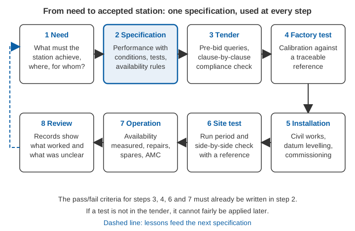
An acceptance test is written into the contract, with pass and fail criteria, and must be passed before the buyer accepts the equipment.
- Factory acceptance test (or pre-dispatch inspection): each sensor is checked against a reference before it leaves the factory, and its calibration certificate is handed over.
- Site acceptance test: after installation, the station runs for an agreed period, with a check of every function and a comparison with an independent reference.
The comparison is the most informative part. For a level station, the reference is a staff gauge or wire-weight gauge at the same section, which WMO-No. 1044 calls the reference gauge, and which should normally be read to the nearest 0.003 m [3]. An illustrative excerpt from a site test:
| Staff gauge (m) | Station (m) | Difference (mm) |
|---|---|---|
| 1.120 | 1.124 | +4 |
| 1.350 | 1.347 | −3 |
| 1.800 | 1.806 | +6 |
| 2.410 | 2.412 | +2 |
| 2.950 | 2.945 | −5 |
| 3.400 | 3.401 | +1 |
| 3.880 | 3.888 | +8 |
| 4.300 | 4.298 | −2 |
Mean difference  = (4 − 3 + 6 + 2 − 5 + 1 + 8 − 2) / 8 = 11 / 8 = +1.4 mm
Standard deviation of differences = 4.5 mm
Largest difference = 8 mm
If the tender said, for example, "mean difference within ±5 mm and every difference within ±10 mm, over at least eight paired readings spanning at least half the expected stage range", this station passes. If it said only "accuracy ±10 mm", the two sides could argue over whether that means the mean or the largest error. Write the rule in full, including who reads the reference.
Calibration and traceability
Ask for a calibration certificate for each sensor, showing the reference used, the conditions during calibration and the results, with a chain of comparisons back to national standards (traceability). In India, the National Accreditation Board for Testing and Calibration Laboratories accredits calibration laboratories to ISO/IEC 17025 [5]. Also specify how the supplier will check calibration in the field during warranty and maintenance, and with what equipment.
Warranty, annual maintenance and spares
State the warranty period, what it covers (parts, labour, travel, communication charges), and the annual maintenance contract (AMC) that follows. Specify the maximum time to repair, which can reasonably be shorter during the monsoon, a list of mandatory spares held locally, and a period for which spares and support must remain available.
Uptime and data availability, and how they are measured
"98 % uptime" is meaningless until three questions are answered. What counts as a value? A value received, or a valid value? What is expected? Every scheduled value, or only those during periods the station was meant to run? What is excluded? Outages caused by the buyer, by a flood that destroys the bridge, or by the network operator?
A good definition counts valid values, not just received ones, so that a flat line or a spike does not count as data. See data quality control for hydromet time series. State the period over which availability is computed (monthly, quarterly), whether it is per station or across the network, and what happens below the target. The calculator below shows how much the definition matters.
Figures in the calculator are illustrative. With the default values, 4,320 values are expected, and availability is 95.1 % counting received values but 93.1 % counting valid values only.
Training and documentation
Specify classroom and field training for the people who will run the network, with named topics: installation checks, calibration, data retrieval, troubleshooting and routine maintenance. Ask for operation and maintenance manuals, as-built drawings and a record for each station (location, datum, sensor serial numbers, calibration dates) that is handed over at site acceptance.
What Indian RTDAS tenders already contain
Public tender documents for real-time data acquisition systems (RTDAS) under the National Hydrology Project already address many of these points. One bidding document published by the Central Water Commission in January 2019 for stations in the North Eastern states, for example, includes [6]:
- a specification table for radar level sensors that states site conditions (ambient temperature, humidity, altitude) alongside range, resolution and accuracy;
- a requirement that remote stations store data for at least one year, and that the bidder states how calibration will be done during warranty and AMC;
- calibration documents with an audit trail to national standards and a record of the conditions during calibration;
- site acceptance testing in two stages, the second a fifteen-day run in which an average data acquisition efficiency of 95 % is considered satisfactory;
- written definitions of invalid data (out-of-range values, sudden unphysical jumps, values stuck while the river changes, and values that disagree with a co-located observation), of a failed transmission and of a faulty station;
- maximum repair times that are shorter in the monsoon (48 hours) than outside it (120 hours), and maintenance payments in proportion to the percentage of data received, with the formula written out.
State water resources departments have published similar documents, including invitations for estimates that ask for rates covering several years of operation and maintenance alongside supply [7].
Common pitfalls
- Copying a datasheet. A datasheet describes what one product does, not what you need. Copied into a tender, it excludes equivalent products and still leaves out conditions, tests and availability rules [1][2].
- "Accuracy" without conditions. A percentage of full scale changes with the range chosen, and a laboratory figure may not hold in rain, sun or turbulent water [3][4].
- No definition of data availability. Without one, a target cannot be measured, and payments linked to it cannot be enforced.
- No acceptance test. If the test and its pass criteria are not in the tender, they cannot fairly be imposed after award.
- Equipment for a different purpose. A sensor suited to a reservoir may not suit a steep, debris-laden hill river; see how to choose a river water level sensor.
An illustrative specification for a river level station
The table below is written in performance terms. The numbers are illustrative and must be set for each site and purpose.
| Item | Requirement (illustrative) |
|---|---|
| Purpose | Flood warning and stage record at a bridge section |
| Measured quantity | Water level (stage) relative to the gauge datum |
| Range | Stage 0 to 12 m; distance from sensor to lowest water up to 18 m |
| Uncertainty | Within ±10 mm of the reference gauge at 95 % probability over the full range, in air temperatures of 0 to 45 °C, in rain and with surface waves up to 0.2 m high, for the installed station |
| Resolution | 1 mm |
| Sampling and averaging | Each logged value is the mean of readings over 30 s, ending at the time stamp |
| Logging interval | 15 min; 5 min when stage rises faster than 0.2 m per hour |
| Time | IST, end of interval, clock kept within ±10 s |
| Local storage | At least 12 months of data; backlog sent automatically when the link returns |
| Latency | 95 % of values on the server within 10 min of their time stamp |
| Data format and access | Documented open format and protocol; buyer owns all data; documented API and bulk export, continuing after contract end |
| Power and autonomy | Solar with battery; 7 days of full operation at the 5-min interval with no charging |
| Environment | Altitude to 2,500 m; air temperature −5 to +50 °C; humidity to 100 %; exposed to lightning and flood spray |
| Installation | Drawings per site; sensor levelled to the gauge datum from a reference mark; staff gauge installed at the same section |
| Factory test | Each sensor compared with a calibrated reference over its range; certificate traceable to national standards |
| Site acceptance | 15-day run; at least 8 paired readings with the staff gauge spanning half the range; mean difference within ±5 mm and every difference within ±10 mm |
| Data availability | At least 95 % valid values per station per month, computed as defined in the contract |
| Maintenance | Repair within 48 h (monsoon) and 120 h (other months); mandatory spares listed and held in the state |
| Training and documents | Field and classroom training; O&M manuals; station records handed over at acceptance |
A checklist before you publish
- [ ] The purpose of the data is written down.
- [ ] Every measured quantity has range, uncertainty with conditions, resolution, averaging and logging interval.
- [ ] Latency, time stamp convention, formats, data ownership and API access are stated.
- [ ] Autonomy is stated at the worst case, and a power budget is requested.
- [ ] Site conditions are described.
- [ ] Civil works, levelling to datum and reference gauges are included.
- [ ] Factory and site acceptance tests have written pass and fail criteria.
- [ ] Calibration certificates and traceability are required.
- [ ] Warranty, AMC, repair times and spares are specified.
- [ ] Data availability is defined, with its formula, period and exclusions.
- [ ] Training topics and documents are listed.
- [ ] No brand names, model numbers or features that only one product has.
Key points
- Specify what the station must achieve, not which product to buy; Indian procurement rules already ask for functional, measurable, brand-neutral specifications.
- Give every measured quantity a range, an uncertainty with its conditions and probability, a resolution, an averaging window and a logging interval.
- Treat data delivery, ownership and access as requirements, not afterthoughts.
- Write acceptance tests, including a side-by-side comparison with a reference, into the tender with clear pass criteria.
- Define data availability precisely: valid values, the expected count, the period and the exclusions.
ClimMaTech works on flood early warning and hydromet monitoring from Mandi in Himachal Pradesh, where the questions in this article come up in every project. Our approach to real-time networks is described on our RTDAS and hydromet telemetry page.
References
- Ministry of Finance, Department of Expenditure, General Financial Rules 2017 (amended up to 31 July 2024), Chapter 6, Rule 144 (fundamental principles of public buying). Copy hosted by the Ministry of Panchayati Raj (PDF), listed at panchayat.gov.in.
- Ministry of Finance, Department of Expenditure, Manual for Procurement of Goods, second edition, 2024, Chapter 2 (paras 2.1, 2.2.1, 2.2.2 and 2.4). doe.gov.in (PDF).
- World Meteorological Organization, Manual on Stream Gauging, Volume I: Fieldwork, WMO-No. 1044, 2010, Chapter 4 (4.2.1 gauge definitions, 4.2.3 stage accuracy requirements, 4.4 recorders, telemetry and timers). old.wmo.int.
- World Meteorological Organization, Guide to Instruments and Methods of Observation, Volume I: Measurement of Meteorological Variables, Chapter 1 "General", section 1.6 and Annex 1.A (operational measurement uncertainty requirements and instrument performance), WMO-No. 8, 2024 edition. WMO publication page.
- National Accreditation Board for Testing and Calibration Laboratories (NABL), Accreditation schemes: calibration laboratories (ISO/IEC 17025). nabl-india.org.
- Central Water Commission, Bidding Document: Supply, Installation, Testing, Commissioning and Maintenance of Real Time Data Acquisition System (RTDAS) of North Eastern States (except Assam) under National Hydrology Project, ICB No. NHP/2019-RDC-1/01, January 2019, Sections VII and IX. cwc.gov.in.
- Water Resources Department, Government of Maharashtra, Invitation of Rates for Preparation of Estimates: Implementation of Real Time Data Acquisition System (RTDAS) for river basins in Maharashtra, December 2014. maharashtra.gov.in%20for%20river%20basins%20in%20Maharashtra%20(India).pdf).