
Weather station siting: heights, obstacles and exposure
Where to put a weather station, how high each sensor should be, and how far it must stand from buildings and trees, following WMO and Indian guidance.

A weather station can have excellent sensors and still give poor data. A rain gauge beside a wall misses rain, a thermometer over a concrete yard reads warm, and an anemometer behind trees reads light winds. WMO's guide notes that errors from poor exposure "may be much larger than those expected from the instrument system in isolation" [1]. Weather station siting, meaning where the station stands and how each sensor is exposed, therefore matters as much as the instruments. This article sets out the rules, from the WMO Guide to Instruments and Methods of Observation (WMO-No. 8) [1] and Indian practice [3][4].
How the sensors themselves work is covered in what is an automatic weather station.
What are the weather station siting guidelines?
The main international guidance is WMO-No. 8. For a typical climatological or synoptic station it asks for [1]:
- Level ground, preferably at least 25 m × 25 m where there are many instruments, covered with short grass or a surface typical of the area, with an open fence to keep people and animals out.
- No steep slopes nearby, and not in a hollow, or the readings will reflect purely local conditions.
- Distance from trees, buildings and walls. For the rain gauge, an obstacle should be at least twice its height above the gauge rim away, and preferably four times.
IMD's satellite-linked AWS network (see India's automatic weather station and rain gauge networks for the networks in use today) used similar norms: a fenced plot of 12 m × 15 m with the fence at least 5 m from the mast, no tall buildings, trees, large water bodies, industrial heat sources or high-tension cables nearby, no steep slope, high vegetation or ground that holds water after rain, and wind sensors at least ten times an obstruction's height away from it [4].
Siting classes 1 to 5
Real sites rarely meet every rule, so WMO-No. 8 adds a siting classification, set out in Annex 1.B to Volume I, Chapter 1 and also published as ISO 19289 [1]. Each variable gets its own class, from 1 (a reference site) to 5 (nearby obstacles make the reading unsuitable for representing a wide area). A site's overall class, if one is needed, is the worst of its variable classes. A high class does not make the data useless; it records what the data represent [1].
| Class | Air temperature and humidity | Precipitation | Wind at 10 m |
|---|---|---|---|
| 1 | Over 100 m from heat sources, reflective surfaces and water; no shade when sun is above 5° | Low obstacles of uniform height at 2–4 H all round, or a wind-shielded gauge with obstacles at 4 H or more | Obstacles at 30 H or more |
| 2 | Over 30 m from them; no shade above 7° | Obstacles at 2 H or more (up to 5 % added uncertainty) | Obstacles at 10 H or more (up to 30 %) |
| 3 | Over 10 m from them; vegetation under 25 cm (up to 1 °C) | Obstacles beyond 1 H (up to 15 %) | Obstacles at 5 H or more (up to 50 %) |
| 4 | Heat sources cover under 50 % of a 10 m radius and under 30 % of a 3 m radius; no shade above 20° (up to 2 °C) | Obstacles beyond 0.5 H (up to 25 %) | Obstacles at 2.5 H or more (over 50 %) |
| 5 | Worse than class 4 (up to 5 °C) | Obstacles closer than 0.5 H (up to 100 %) | Worse than class 4 |
H is the obstacle's height (above the gauge rim for precipitation). Figures in brackets are WMO's estimate of the extra uncertainty that siting adds. Temperature and precipitation classes 1 and 2 also need flat land with slopes under about 19°, and temperature classes 1 and 2 need low natural vegetation under 10 cm. Condensed from WMO-No. 8, Volume I, Chapter 1, Annex 1.B [1].
What is the ideal height for a weather station?
There is no single height: each sensor has its own standard height, chosen so that readings from different stations can be compared.
- Air temperature and humidity: 1.25–2 m above natural ground, preferably grass, inside a radiation screen. The height should never be below 1.25 m; between 1.5 and 2 m the difference is usually under 0.2 °C [1].
- Wind: 10 m above open ground, meaning obstacles at least ten times their height away [1].
- Rain gauge rim: 300 mm in India. IS 4986 requires the rim to be horizontal and "exactly 300 mm above ground level": lower, and rain splashes in; higher, and wind eddies around the gauge reduce the catch [3]. Worldwide, rim heights of 0.5 to 1.5 m are most common, so records from different countries are not strictly comparable [1].
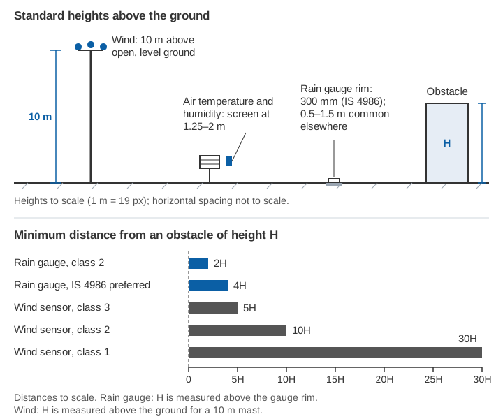
Where trees or buildings above 2 m surround the site, WMO suggests mounting wind sensors 10 m above the obstacles' mean height [1]. Where the surroundings vary little with direction, an anemometer at about 13 m over terrain with a roughness length of 0.1 m, or about 19 m with 0.5 m, can stand in for the 10 m reading [1].
Where is the best place to put a weather station?
The best place is open, level, natural ground typical of the area it should represent, away from buildings, trees, paved surfaces and water. WMO offers a test for terrain: if moving the station 500 m would not change its class, the relief is a natural feature of the area and is not counted against the site [1].
Worked example: one compound, three answers
A district office offers a lawn beside a 6 m building, with a row of 12 m trees on one side. Applying the rules (illustrative):
Rain gauge, rim at 0.3 m (class 2: 2 H above the rim; IS 4986 preferred: 4 H)
  Building: 2 × (6 − 0.3) = 11.4 m        preferred 4 × 5.7  = 22.8 m
  Trees:    2 × (12 − 0.3) = 23.4 m       preferred 4 × 11.7 = 46.8 m

Wind sensor at 10 m (class 2: 10 H; class 1: 30 H)
  Building: 10 × 6 = 60 m                 class 1: 180 m
  Trees:    10 × 12 = 120 m               class 1: 360 m

Temperature screen at 1.5 m (class 2: no shade with the sun above 7°)
  tan 7° = 0.123
  Building: (6 − 1.5) / 0.123 = 36.6 m
  Trees:    (12 − 1.5) / 0.123 = 85.4 m
The shading distance applies only to obstacles on the sun's side. The rain gauge can sit comfortably on such a lawn, a class 2 temperature site is possible, and a class 2 wind site probably is not. Wind is usually the hardest variable to site, which is why WMO notes the enclosure may not be the best place to measure it [1].
Site selection for a rain gauge station
Wind is the largest source of error in rainfall measurement, so a rain gauge needs some shelter but not too much. Very open sites lose catch in anything but light wind, while close obstacles cause eddies [1]. The rules [1][3]:
- Level ground, never on a slope, terrace, wall or roof, and never where the ground falls away steeply on the windward side.
- Obstacles at least twice their height (above the rim) away, preferably four times; a belt of trees or a wall at that distance on the side of the prevailing wind gives good shelter at windy hill and coastal stations.
- Short grass, gravel or shingle around the gauge, not concrete, which splashes rain in.
- In flood-prone areas, the gauge at least 300 mm above the highest flood level.
IMD's AWS network placed the rain gauge at least 3 m from the mast [4]. Installation details are in types of rain gauges used in India, errors of automatic gauges in tipping-bucket rain gauge errors, and the spacing of gauges across a district in how many rain gauges a district needs.
Roofs, slopes and towns
Roofs. WMO calls temperatures measured on top of buildings "of doubtful significance", because the building alters the air around it [1]. A wind sensor on a roof should stand at least one building width above the roof [1]. In towns, WMO advises avoiding rooftop sites for everything except incoming solar radiation unless instruments are on a tall mast [2].
Towns. Local effects are stronger in towns than in the countryside [1]. Temperature measured among buildings can represent its neighbourhood if the site is chosen carefully, and rain can be measured near the ground at an unobstructed spot [2]. Complex terrain and urban sites usually end up in class 4 or 5, and WMO allows an "S" flag (for example 4S) to mark a site chosen for a specific purpose [1].
Hills. Hill and coastal stations are often unrepresentative of the wider area [1]. On a mountainside, IS 4986 asks for a patch whose slope and orientation match the surroundings, on stable ground [3]. At coastal sites, keep away from cliff edges, whose eddies disturb wind and rain [1]. See river monitoring in hill and Himalayan catchments.
Record the site, and check it again
Sites change as trees grow and buildings go up. WMO recommends a yearly visual check, a full reclassification at least every five years, and a site map with obstacle heights; for wind, a map covering 2 km around the station [1]. IS 4986 asks for a sketch of surrounding objects with their heights and distances, and inspections at least twice a year, one before the monsoon [3]. IMD documented its AWS sites with photographs [4]. These records let data users judge what a station represents.
Key points
- Sensor heights are standard: temperature and humidity at 1.25–2 m, wind at 10 m, and the manual rain gauge rim at 300 mm in India.
- Keep obstacles at least twice their height from a rain gauge (preferably four times) and at least ten times their height from a 10 m wind sensor.
- WMO's classes 1 to 5 grade each variable separately and estimate the uncertainty that siting adds.
- Avoid rooftops, slopes, hollows, concrete and nearby water; shade and wind exposure usually decide the site.
- Map and photograph the site, recheck it yearly and reclassify it at least every five years.
Where ClimMaTech fits
Rainfall and temperature data feed the river and flood work we do, and their value depends on careful siting. VARSHAQ, our weather station, is in development. Rain gauges and weather stations can report alongside river stations in one real-time network, as described on our RTDAS and hydromet telemetry page, and our approach to warnings is on the flood warning page.
References
- World Meteorological Organization, Guide to Instruments and Methods of Observation, Volume I: Measurement of Meteorological Variables, Chapter 1 "General" (section 1.3.3 and Annex 1.B "Siting classifications for surface observing stations on land"), Chapter 2 "Measurement of temperature", Chapter 5 "Measurement of surface wind" and Chapter 6 "Measurement of precipitation", WMO-No. 8, 2024 edition. WMO e-Library.
- World Meteorological Organization, Guide to Instruments and Methods of Observation, Volume III: Observing Systems, Chapter 9 "Urban observations", WMO-No. 8, 2024 edition. WMO e-Library.
- Bureau of Indian Standards, IS 4986:2002 Installation of raingauge (non-recording type) and measurement of rain – Code of practice (second revision), BIS, 2002. archive.org (Public.Resource.Org, archived copy).
- M.R. Ranalkar, R.P. Mishra, A. Anjan and S. Krishnaiah, Network of Automatic Weather Stations: Pseudo random burst sequence type, MAUSAM, 63(4), 587–606, 2012. doi:10.54302/mausam.v63i4.412.