
Keeping stations reporting in floods: power and link backup
How a telemetry system loses power or signal at the worst moment, and the layered design that keeps flood data flowing.

The heaviest rain of the season is exactly when a river station matters most, and it is also when the station is most likely to go quiet. Mains power fails, mobile towers lose their own supply, a cloudy week starves the solar panel, and the flood itself reaches the equipment. Anyone planning a telemetry system for water management has to design for that moment, not for a sunny commissioning day. This article explains how telemetry systems work, where they fail in floods, and how layered power and communication backup keeps data flowing.
How do telemetry systems work?
A telemetry system measures a quantity at a remote site and delivers it to a distant place without anyone visiting. In a river station the chain has four parts: a sensor (for example a radar water-level sensor), a controller with data logger that samples and records, a communication link (mobile network, satellite or radio), and a receiving server that stores and displays the data. A fifth part is easy to forget: the power system that keeps the first four alive. We describe the full path in from sensor to screen and the receiving side in what is an RTDAS.
India's national flood forecasting network works this way. The Central Water Commission (CWC) reports telemetry equipment at 1,121 stations for water level and rainfall, with satellite earth receiving stations at Burla, Jaipur and New Delhi, and 27 modelling centres. Data moves "through Satellite/GSM/GPRS in case of automated stations", and mobile or telephone links serve "as a back-up/supplementary mode of communication" [2]. So even the national network treats communication as a set of alternatives, not a single path.
Why do stations go silent in a flood?
Stations fail in floods for a handful of repeating reasons.
- The site loses power. A station on mains with no battery stops when the grid does. A solar station can run flat after several overcast days.
- The link goes down. Mobile towers have their own power and backhaul, and both can fail.
- The equipment is hit directly. Water reaches a cabinet mounted too low; lightning arrives with the storm.
- Nobody can reach the site. A silted panel or a loose battery lead stays that way when the road is cut.
The mobile-network case is well documented. After the torrential rain of late August 2025, 1,155 of 1,761 telecom sites in Chamba district of Himachal Pradesh (about 66 %) were non-functional on 27 August. By 2 September, 374 were still down. In Kullu district, the share of operational sites differed sharply by operator: about 85 % of one operator's 877 sites, 65 % of another's 1,173 sites and 20 % of a state operator's 391 sites [3]. The report attributes the damage to incessant rain, with fibre repairs expected to take about a week at one location [3]. For a hydromet station, that means a single SIM from a single operator can be silent for days while another operator's network in the same valley is working.
How do you design for power failure?
The WMO Manual on Stream Gauging describes the baseline: gauging stations mostly run on dc batteries, with ac mains used where "a reliable source of ac current is available". A mains-fed system "should be equipped with an appropriate Uninterrupted Power Supply (UPS) and surge protector" [1]. The manual also warns that data collection platforms with telemetry can use considerably more power than a simple electronic data logger, so a solar-charged system must be checked to ensure it is "adequate to keep them operational" [1]. That sentence is the whole design problem in miniature.
A layered power design has four elements.
- A battery sized for days, not hours. The battery is the station's only supply during a week of cloud. How many days of autonomy to provide is a judgement about local weather and how soon a crew can reach the site. Sizing solar power for an off-grid monitoring station shows the method.
- A solar panel sized for the worst month. In the monsoon the panel may deliver only a fraction of its clear-sky energy, and that is the season of floods.
- A charge controller that protects the battery. IEC 62509 sets minimum requirements for the functioning and performance of battery charge controllers in photovoltaic systems, with the aims of controller reliability and long battery life [4]. Be aware that the standard is written for lead-acid batteries. Other chemistries have their own charging limits, especially in cold weather, as discussed in batteries in the cold.
- Low-power behaviour. A station that sleeps between readings and sends only when needed leaves more energy for the days when the sun is absent. This leads to the most important design choice below.
A worked energy budget (illustrative)
The numbers below are illustrative and not the specification of any product. They show how reporting rate changes the energy a station uses.
| Item | Assumption | Energy per day |
|---|---|---|
| Sensor, controller and logger, always on | 0.4 W average × 24 h | 9.6 Wh |
| Reporting hourly | 24 sends × 20 s × 2.5 W ÷ 3,600 | 0.33 Wh |
| Reporting every 5 minutes | 288 sends × 20 s × 2.5 W ÷ 3,600 | 4.0 Wh |
Hourly reporting uses 9.6 + 0.33 = 9.9 Wh a day. Five-minute reporting uses 9.6 + 4.0 = 13.6 Wh a day, about 37 % more. Now take a 12 V, 20 Ah battery, which stores 12 × 20 = 240 Wh, and allow only half of it to be used, 120 Wh, to protect the battery. With no sun at all:
Hourly reporting:      120 Wh ÷ 9.9 Wh/day  = 12.1 days
5-minute reporting:    120 Wh ÷ 13.6 Wh/day = 8.8 days
Two lessons follow. First, the always-on load dominates, so a small saving in baseline consumption matters more than trimming transmissions. Second, reporting faster costs real energy, so the best practice is to report slowly in normal conditions and speed up when the river rises. We discuss when a rise should trigger faster reporting in rate-of-rise alerts and the quiet-time behaviour in edge computing in field devices. Poor signal raises the real transmit cost, because a modem that retries or searches for a network draws power for much longer than 20 seconds. The assumed 2.5 W and 20 s should therefore be measured at the actual site.
How do you keep the link alive?
The same layering applies to communication.
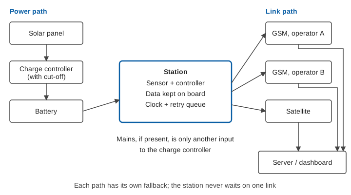
Store and forward. The first backup is on the station itself. If every link is down, the controller keeps recording with the correct time stamp and sends the backlog when a link returns. The record then has a gap in time of arrival but not a gap in the data. This is why integrated data logging matters in a flood: the data exists even when no one can see it live. Reliable clocks are part of this, see time stamps you can trust.
Two mobile operators. The Kullu figures above show that operators recover at different speeds [3]. A second SIM on a different operator is the cheapest form of link redundancy, provided both operators have coverage at the site. Check this in the field before commissioning, because coverage in a gorge can be very different from that in the valley.
A narrowband cellular option. For low data volumes the 3GPP standards body developed, in Release 13, three technologies for the internet of things: EC-GSM-IoT, LTE-M and NB-IoT. The 3GPP describes NB-IoT as offering energy-efficient operation, and it can run within an LTE carrier or in its guard band [5]. Availability varies by operator and place, so confirm it for your site rather than assuming it. It shares the weakness of any cellular link: it needs the tower.
Satellite. A satellite link does not depend on local towers. The WMO manual notes that for a station "situated in a remote location" where "automatic real-time data collection is required as in flood warning systems, satellite transmission may be the only option", while adding that it can be expensive when data are sent at short intervals [1]. In practice, a satellite link is best kept for a small, important message, such as the water level and battery voltage, sent at a longer interval or when a threshold is crossed. CWC's own design reflects this: its satellite chain runs alongside GSM/GPRS and mobile links [2]. Telemetry link design for hydromet stations compares the options in more detail.
A manual fallback. Gauge boards and observers remain the last layer. The WMO manual describes an auxiliary gauge read by a local observer "to continue the record of stage during the malfunction" [1]. A phone call to a district control room costs nothing in battery.
What else protects a station in a flood?
Power and link backup protect against outages. Three other measures protect against damage.
- Mount above the flood. The WMO manual places shelters that do not need a stilling well "above the reach of floodwaters" [1]. Mount the cabinet and panel above the highest recorded flood, and plan for debris.
- Lightning and surge protection. WMO notes that a lightning-protection system is "needed for gauging structures to ensure uninterrupted data collection", with surge suppressors on power and telephone lines, transient protectors on antenna cables and a low-resistance earth, and that even so, "a direct lightning strike will likely destroy the electronic components" [1]. See lightning and surge protection for remote field stations.
- Maintenance before and after the flood. CWC's maintenance procedure calls for cleaning solar panels, battery leads and terminals "monthly or after every heavy rainfall or dust storm or cyclonic storm or flood or disruption in data transmission" [2]. A post-monsoon checklist turns this into practice.
Testing the backup
A backup that has never been tested is an assumption. Before each monsoon, switch off the mains or disconnect the panel and check that the station keeps running; remove the primary SIM and check that the second path takes over; and confirm that data buffered during an outage appears with its original time stamps. Our pre-monsoon readiness checklist includes these tests.
Key points
- Floods cause power and communication failures together, so backup must cover both.
- Size the battery for days without sun, and the panel for the cloudiest month, not for a clear day.
- The always-on load dominates energy use; report slowly in calm weather and faster when the river rises.
- Keep a local record on the station and forward it when a link returns.
- Use independent link paths, such as two mobile operators, with satellite where towers cannot be relied on.
- Test every backup each year; an untested backup is only an assumption.
Where ClimMaTech fits
At ClimMaTech, our monitoring devices keep an on-board record and report over GSM, so the record is kept even when the network is down. Our RTDAS and hydromet telemetry solution page describes how stations, links and the receiving platform fit together, and PRAVAAH, our non-contact radar sensor for water level and surface velocity, is built for these remote river sites.
References
- World Meteorological Organization, Manual on Stream Gauging, Volume I: Fieldwork, WMO-No. 1044, 2010, sections 4.3.3, 4.4.4 and 4.4.6 and the discussion of shelters. PDF
- Central Water Commission, Ministry of Jal Shakti, Standard Operating Procedure for Flood Forecasting, April 2026, sections 1.2, 1.4.1, 3.6.1, 3.7 and Annex-1.6 on upkeep of telemetry stations. PDF
- Network connectivity in state improves as 65 sites restored, The Tribune (Himachal edition), 4 September 2025. tribuneindia.com
- International Electrotechnical Commission, IEC 62509:2010, Battery charge controllers for photovoltaic systems: Performance and functioning, edition 1.0, 2010. webstore.iec.ch
- 3GPP, The Cellular Internet of Things, 3GPP news, October 2017. 3gpp.org