
Flash Flood Guidance Systems (FFGS) explained
How a flash flood guidance system turns rainfall estimates and soil moisture into a threat map, how South Asia's version works, and where ground data still matters.

A cloudburst over a steep Himalayan side valley can turn a dry stream into a wall of water in under an hour. There is rarely a river gauge upstream to warn anyone, and a weather forecast that says "heavy rain" does not say which valley will flood. A flash flood guidance system (FFGS) is built for exactly this gap: it tells forecasters, basin by basin, how much rain would be enough to flood a stream, and compares that with the rain that is falling or forecast. This article explains how a flash flood guidance system works, what the South Asia FFGS run by the India Meteorological Department (IMD) provides, and what its limits are.
What is a flash flood guidance system?
A flash flood guidance system is a set of software and data products that estimates, for each small stream basin, the rainfall needed to cause flooding, and flags the basins where actual or forecast rainfall exceeds it. It was designed by the Hydrologic Research Center (HRC), a US non-profit, for use by meteorological and hydrological forecasters, and it supports hourly to six-hourly assessments for basins of roughly 25 to 200 km² [1].
The idea is a change of question. A river-flood model asks "what will the hydrograph look like?" A flash flood guidance system asks "has the rain on this small basin already passed the amount that fills the stream to its banks?" Large rivers respond slowly and a full hydrograph can be forecast, but flash floods respond within hours and the main interest is whether one will occur [1][2]. For why small catchments react so fast, see time of concentration, and for how warning time differs between the two flood types, see flash floods vs river floods.
The system is a global programme run by the World Meteorological Organization (WMO) with the US National Weather Service, USAID and HRC. WMO describes it as providing early warnings to about three billion people in more than 60 countries [3]; its 2017 brochure listed eight regional systems covering 52 countries [2].
How does flash flood guidance work?
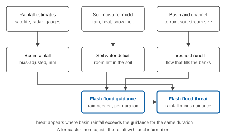
Flash flood guidance (FFG) is the depth of rainfall, over a given duration and over one small basin, needed to bring the stream at the basin outlet to bankfull flow [1][2]. Durations up to six hours are used, typically one, three and six hours [2]. It is computed from two ingredients:
- Threshold runoff: the amount of runoff, worked out once for each sub-basin from terrain, soils, land cover and the stream network, that fills the channel to its banks. In the United States this was mapped using GIS [4].
- Soil water deficit: how much water the soil can still absorb. A soil moisture model is updated continuously from rainfall, temperature and evapotranspiration, and, in snowy regions, from a snow model [1][2]. Dry soil soaks up rain and delays runoff; saturated soil passes almost all of it on.
So the same 40 mm of rain can be harmless on a dry slope and dangerous after a wet fortnight. The guidance is not a fixed number: it rises and falls with the state of the soil [1][5].
What is the flash flood threat?
The flash flood threat is the amount by which the basin's mean rainfall over a given duration exceeds the guidance for the same duration [2]. If it is zero or negative, the rain has not yet reached the bankfull level. If it is positive, flooding is likely in that basin. In the forecaster's interface, threat is offered in three forms [1]:
- Imminent threat: from rainfall that has already fallen, a current "observation" of the threat.
- Persistence threat: assuming that the rain of the previous period will be repeated over the same duration ahead.
- Forecast threat: using rainfall forecast by a weather model.
A worked example (illustrative)
Take one small basin and a three-hour window. Suppose the basin has had 42 mm of rain in three hours, and the model's guidance for three hours changes with soil state as follows (numbers invented to show the arithmetic):
| Soil state | 3-hour guidance (mm) | Rain in 3 h (mm) | Threat (rain − guidance, mm) |
|---|---|---|---|
| Dry | 70 | 42 | −28 (no threat) |
| Moist | 50 | 42 | −8 (no threat) |
| Wet | 30 | 42 | +12 (threat) |
The point is the comparison, not the numbers: identical rainfall produces a warning only once antecedent wetness has used up the soil's storage.
What is the South Asia Flash Flood Guidance System?
The South Asia FFGS (SAsiaFFGS) is the regional version of the system for Bangladesh, Bhutan, India, Nepal and Sri Lanka, with IMD as its regional centre. It was officially launched on 23 October 2020 and covers nearly 1.6 billion people. It was funded by USAID's Bureau for Humanitarian Assistance and implemented by WMO and HRC, with NOAA supplying satellite data [3].
According to WMO's launch announcement [3]:
- Its products are threats, issued 6 hours in advance, and risks, issued 24 hours in advance, to support impact-based forecasting at watershed and city level.
- Since September 2020 IMD has issued daily regional flash flood advisories to the five countries, with lead times of up to 36 hours.
- It is used by national meteorological and hydrological services, State Disaster Management Authorities and other stakeholders.
- An online course in July 2020 trained 130 forecasters from the five countries.
- Officials called for a stronger rainfall and soil moisture observation network, automated dissemination through social media, and stronger regional coordination.
How such guidance reaches the public depends on the chain after the forecaster: who issues a warning in India is covered in who issues warnings in India, and how a guidance product becomes a message about likely impacts in impact-based forecasting.
What the system does well
- It covers basins nobody gauges. Most small hill streams have no river gauge, but satellite and radar rainfall estimates can cover them. WMO describes the system as using remote-sensed precipitation and hydrologic models to support warnings of small-scale flash flooding [1].
- It is built for forecasters. The products are designed to be evaluated, interpreted and adjusted by operators with meteorological or hydrological expertise, with room for local rain gauge reports, weather model output and last-minute observations [1][2].
- It is cheap to run over large areas. Distributed hydrological models give full hydrographs but are expensive to run in real time at high resolution over very large areas, and have high uncertainty on small scales. Guidance estimates only bankfull flow and can examine all flash-flood-prone basins over a large region [1].
- It is a shared platform. Neighbouring countries see the same products, which matters for rivers that cross borders such as those in the Himalaya.
What it cannot do alone
Being honest about limits is part of using the system well.
- It indicates likelihood of flooding, not where the water will go. Guidance is for the basin outlet; it does not map the inundation or the velocity of a debris-laden flow in a particular village.
- Satellite rainfall is an estimate. The satellite estimates the system ingests are bias-adjusted using real-time rain gauges where they exist [1][2], so quality falls where gauges are few. Intense convective cells over narrow hill valleys are small and short-lived, which makes them hard for any rainfall estimate to capture.
- Soil moisture is modelled, not measured. The soil water deficit comes from a model driven by those same rainfall estimates, so errors carry through. Published work on the uncertainty of flash flood guidance, and on moving towards probabilistic forecasts, exists for this reason [6].
- Other flash flood causes are outside the rainfall concept. Guidance concerns heavy rainfall and rainfall on saturated soil [2]. It does not itself address landslide dams, glacial lake outbursts or debris flows, which are covered in glacial lake outburst floods and debris flows in Himalayan streams.
- Warnings still need a last mile. A threat map reaches an office, not a household. Reaching people in minutes is a separate design problem; see early warning dissemination.
In our own study of the April 2025 Ramban cloudburst in Jammu and Kashmir, which combined weather simulation, satellite deformation and floodwater mapping, the case for multi-sensor early warning came from exactly this: localised convection cascading into slope failure and flash flooding, with damage along the highway [7].
Why ground data still matters
Every link in the guidance chain depends on measurements on the ground:
- Rain gauges correct the bias of satellite and radar rainfall estimates. A gauge network in the hills is the difference between a rainfall field that is calibrated and one that is only a guess; see how many rain gauges a district needs and weather radar, rain gauges and satellites.
- Stream level and flow show what actually happened after the guidance said it might. A water-level record at the outlet shows whether a threat was real, and over the seasons it helps forecasters judge how far to trust the guidance for that basin. See river monitoring in hill and Himalayan catchments.
- Soil moisture observations are named in WMO's launch announcement among the networks officials wanted strengthened [3].
A guidance system and a local monitoring network are therefore complementary: the first says where to look, the second says what is happening there.
Key points
- Flash flood guidance (FFG) is the rainfall over a small basin, for a given duration, needed to reach bankfull flow; it depends on threshold runoff and on how wet the soil already is.
- Flash flood threat is the rainfall exceeding that guidance. It can be computed from observed rain, persisted rain or forecast rain.
- The South Asia FFGS, operated by IMD since its launch on 23 October 2020, serves Bangladesh, Bhutan, India, Nepal and Sri Lanka, with threat products 6 hours ahead and risk products 24 hours ahead.
- The system is a guide for trained forecasters: it needs local information, and it estimates the flooding likelihood of whole basins, not of a particular site.
- Rain gauges, soil moisture and stream-level measurements are what keep the guidance honest and let local thresholds be tuned.
Where ClimMaTech fits
At ClimMaTech we build the ground-level measurements that a guidance system relies on and that a local warning needs after it. Our river-level and discharge radar sensors and sirens are described on our flood warning page, along with how stations, a cloud dashboard and community alerts can be linked into one local chain.
References
- Hydrologic Research Center / World Meteorological Organization, Flash Flood Guidance Systems (background information), WMO Flood Forecasting Initiative, undated. old.wmo.int
- World Meteorological Organization, Flash Flood Guidance System (FFGS) with global coverage (brochure), 2017. old.wmo.int
- World Meteorological Organization, South Asia Flash Flood Guidance System launched, news release, 23 October 2020. wmo.int
- T. M. Carpenter, J. A. Sperfslage, K. P. Georgakakos, T. Sweeney, D. L. Fread, National threshold runoff estimation utilizing GIS in support of operational flash flood warning systems, Journal of Hydrology 224(1–2), 21–44, 1999. doi:10.1016/S0022-1694(99)00115-800115-8)
- K. P. Georgakakos, Analytical results for operational flash flood guidance, Journal of Hydrology 317(1–2), 81–103, 2006. doi:10.1016/j.jhydrol.2005.05.009
- A. A. Ntelekos, K. P. Georgakakos, W. F. Krajewski, On the uncertainties of flash flood guidance: toward probabilistic forecasting of flash floods, Journal of Hydrometeorology 7(5), 896–915, 2006. doi:10.1175/JHM529.1
- S. Awasthi, A. T. Jose, S. Barbhuiya, A. K. Taloor, D. M. Varade, A. K. Rai, V. Gupta, M. Sharma, D. P. Shukla, Hydro-meteorological and infrastructural damage analysis of the 2025 Ramban cloudburst event in the North-Western Himalayan region of Jammu and Kashmir, India, International Journal of Disaster Risk Reduction 138, 106126, 2026. doi:10.1016/j.ijdrr.2026.106126